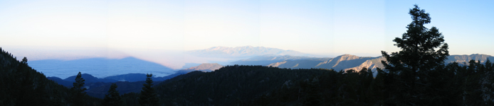
On the trail up to San Bernardino Peak early one morning. I loved the mountain's shadow on the mist.
My lungs were in pretty good shape from the running and biking that I obsessively engage in – abet at sea level. I decided on some local suffering to help get my legs and head into shape for the trip. I have been on Mount San Jacinto in every season and via four different routes. I felt comfortable on the mountain and in the backcountry around it. After looking over my topographical map of the area, I decided to summit San Jacinto, Jean Peak, Marion Mountain and Drury Peak in a day via the Marion Mountain Trail. It is a fairly steep route to 10,000’ and has some great scenery along the way. I figured that the altitude would help as much as the uphill hike and the distance.
I did the hike on a Saturday - going from Marion Mountain Trailhead to Mount San Jacinto in three hours. I jotted my name in the register at the rock-house near the summit and traversed south through a saddle to Jean Mountain. I could see grey skies and rain coming in from the Palm Desert, but figured I would beat the rain to the top of Marion. I dropped down and to the right of a rock outcrop in the saddle between the two, seeing a big doe mule dear in the saddle’s low point. Just as I was starting up the slope of Marion, I found a medium sized tree with bear sign on it. It wasn’t from that specific day, but it was fresh enough to have hair stuck in the sap and to give me the willies as I was doing the trip solo. The weather rolled in just as I could see the summit block of Marion and my hands got a buzz through the rock from a nearby lightning strike about twenty to twenty-five yards shy of the top. It was a little too close for me and I hauled ass down the mountain.
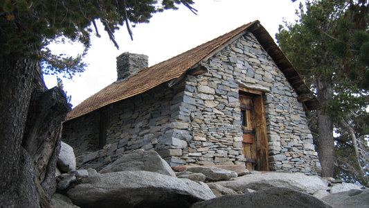
The summit hut on San Jacinto got a new roof this summer. I really love this little stone cabin and it would be amazing to have one like it one day for the kids and I to hike to and use as a basecamp.
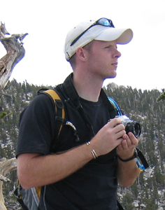
A self-portrait on Drury Peak.
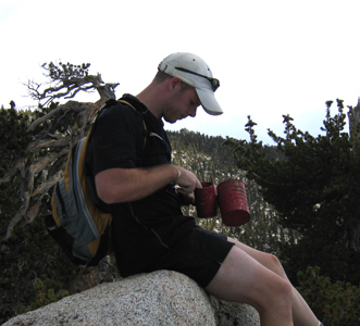
Digging out the summit register on Drury.
Like the hike and ascent the previous weekend, I decided to do a training hike for the Mt. Whitney trip planned for the next weekend. After again pouring over maps (I have a thing for maps if you hadn’t noticed) I decided on doing the nine peak - San Bernardino to San Gorgonio traverse. It is a little jaunt that covers 27+ miles and has over 7,900’ in net elevation gain. I wanted to do it with Brauning as we are going to be on Mt. Whitney together, but he had to go off and frolic on the beach in Bora-Bora and Australia for a couple of weeks. So I enlisted my regular cycling partner, Ron, to come along. Ron is an animal on a bike - centuries, double century, 500 mile races and he almost qualified for the RAAM (Race Across America) before his support team accidentally ran over him. He has the stamina of a lion. Ron has hiked extensively in the Sierra high country and I knew he would be fine. Did I mention that Ron is a grandfather and at the time of our hike was six months away from being 60? That’s right he was a grizzly bear! I hope I am in half the shape that he is in when I am 40…
We stared out at 4:25am on a Saturday after spending
the night at the Angeles Oaks Trailhead. We hiked the first two thirds
of the first peak with headlamps and found ourselves in a high meadow
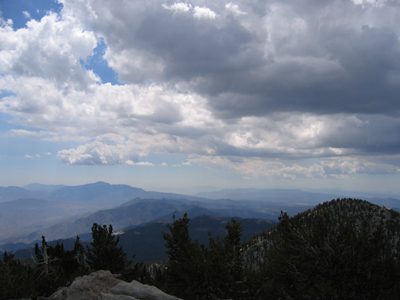
as dawn broke. The sunrise in the mountains was awesome. There was mist
covering the valley behind us and we could see the shadows of the mountains
reflected in blue light on the mist.
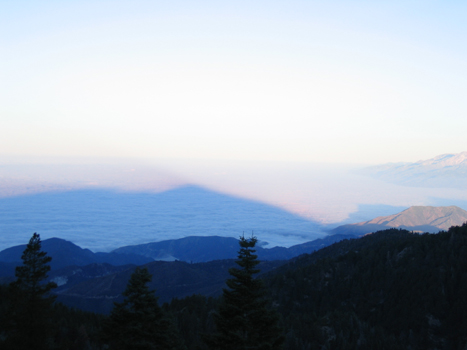
A close-up of the San Bernardino's shadow on the morning mist.
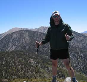
Ron at the summit of Jepson Peak
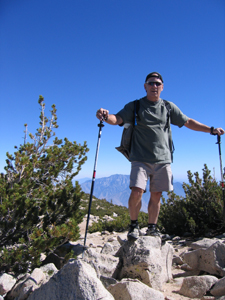
Me standing on the high point of Anderson Peak
The first peak was bagged at 8:30 after an initial 4,500’ of gain and we hauled ass from there – summiting the ninth peak (San Gorgonio 11,501’) at 4:17pm. All nine summits were above 10,000 feet and none were given up easy. Every one, but the first and last, were off the trail a good bit and we had to pull off some third-class scrambling to get to the top of three of them. Our time table for the ascents is below:
Angeles
Oaks Trailhead – 4:25am
San Bernardino Peak – 8:30am
San Bernardino Peak East – 9:25am
Anderson Peak – 10:28am
Shield’s Peak – 11:12am
Alto Diablo – 12:02pm
Charlton Peak – 1:37pm
Little Charlton Peak – 2:17pm
Jepson Peak – 3:25pm
Mount San Gorgonio – 4:17pm
I tried for two years in a row to pull a permit to climb Mt. Whitney. I have lost in the drawing both years. Last year I accepted the defeat with grace and decided to climb anyway. If you have a three or four day window you can show up mid week and put your name in for a drawing at the Visitor’s Center in Lone Pine for permits that were not picked up that day. Don’t even think of trying it on a weekend in the middle of summer! The US forest Service limits the number of people on the trail to 160 per day. Last year Matt Brauning and I were twelve hours away from driving up to attempt a drawing when an early storm covered the area in three feet of snow and there were 100MPH winds measured on the summit ridges. Fearing the loss of toes would be the price for the summit; we retreated from our plans and spent the weekend climbing in Joshua Tree.
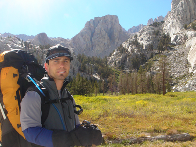
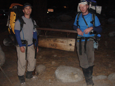
This year there was some schedule juggling as I was in and out of Germany and Brauning was flying all around the South Pacific. We finally agreed to climb on the weekend of the 16th of September, figuring that it would be one of the last weekends that the mountain would be free of snow and we hoped that most of the would-be climbers would have returned to school or work from their summer vacations. As the date neared, I had to pull it back a day as I had a commitment for Sunday night (the 17th) that I refused to break. Brauning agreed to leave early, but only if I drove the whole way and toted the stove and all the food – he bargains and haggles better than me. I agreed, we met at his place on a Thursday night, packed up my truck and headed north on US395.
As I mentioned above, the original plan was to climb Mt. Muir, Mt, Whitney, Mt. Russell, and Mt. Carrolton in one long traversing loop. The weather forecast that weekend called for an Artic front descending on the Northern and Eastern Sierra. That information coupled with a tight return schedule led us to delete the last two summits and making the trip an out and back affair instead the planned loop.
We arrived at the Visitor’s Center at 1:00AM, parked across from the locked gate, and slept in the back of the truck under the camper shell. We were the first ones in line for the same-day access lottery the next morning. Our number was six out of six and they took the first five. I had flashes of mugging another group and running up the mountain with their permit, but good judgment won out and I started begging the Visitor Center staff for just one more pass. After a bit of groveling we were told to come back for a second drawing at 10:45am that day. We spent the next two and a half hours fueling up on breakfast at a local greasy diner and packing all our gear for the trail. We had come way too far to let a little drawing stop us for bagging Mt. Whitney. We stayed really positive about pulling a permit and didn’t even think of what to do with the weekend if we were unsuccessful. There was no “Plan B.” We were going up and that was all there was to it. Our positive affirmations paid off when we drew the number two slot out of sixteen. After signing some papers, giving our personal information, and getting a ‘don’t feed the bears’/’carry your waste out’ lecture, we were off to the Portal and to start the day’s long walk.
The Mount Whitney Portal sits at 8,360 feet and we left the parking lot there at 1:30pm, ascending 6.3 miles and 3,680 vertical feet to Trail Camp at 12,040 feet. The wind blew hard and cold for most of the day. At one point we passed a couple on the trail above Outpost Camp. The guy was wearing a Utilikilt (imagine carpenter’s overalls and a Scottish kilt merged together, and sewn from 12 ounce cotton duct cloth). He raved about how it was just the thing to hike in. About ten minutes later the temperature made its first dip toward the freezing mark. I am willing to bet that dude put big-boy pants on right quick when that cold biting wind blew up his skirt and lashed his nether regions!
Brauning in the meadow below Outpost Camp.
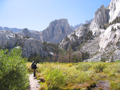
Me standing in the same meadow. Thor Peak rises above me.
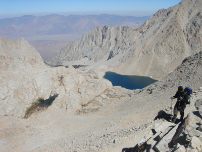
It was, by far, the worst night of my life ever spent in a tent. The temperature dropped to below twenty degrees Fahrenheit, water in the one of the high lakes near camp and its supply/outlet stream froze. We had sustained fifty MPH winds with gusts over sixty. The tent held - mostly, but it beat on us. Our tent was a three season (sans winter…) model so dust and microscopic bits of marmot poop swirled around us all night. It blew in under the fly and there was a thick layer of the gritty mix on everything when the wind stopped sometime after 2:00am. I decided right then and there that I was buying a new four season tent and that I would never subject myself to such torture again! After maybe two hours of sleep Brauning and I pushed for the summit at 7:30am and were on top at 11:30am.
On the trail up there are ninety-nine switchbacks leading to the Trail Crest. On one of these turns we met an older guy with a huge pack who was coming down. He had just finished the entire John Muir trail – walking from Yosemite to Whitney in twenty five days – solo! He was sixty-seven years old and we held him in awe, talking about how that ol’ boy was proof that one is only as old as they say they feel for the whole way to the top of the mountain. I want to be that guy when I am sixty-seven years old! Just a note: I made Brauning dry-heave on the trail up. He wouldn't walk behind me for the rest of the trip. Every one has to have a super power and mine is methane.
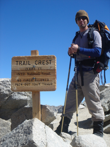
Trail Crest along the Whitney Trail. We were so glad to be done with the 99 switchbacks!
Me coming up to the Trail Crest.
The weather at the summit that day was perfect: very little wind, moderate temperatures, clear blue skies, and a warm sun shinning on us. After being there for just a minute, Brauning started emptying a small Ziploc bag from his pack - looking worried and somewhat crazed - nature was calling & calling LOUDLY. I gave him my waste disposal bag (they give them to you at the trailhead because you have to pack out ALL waste & he left his at camp that morning) and he took care of business in a stacked-rock shelter near the summit hut. He packed away his huge full plastic bag of filth and we sat down to have some coffee and hot cocoa on the summit. It is a little something we do at the tops of peaks that is a nod to the civilized British climbers of the past and a way for us to show the mountain that not only did we make it up its slopes, but that we have enough left in us to enjoy a little life on the summit. For about an hour Brauning and I were the highest two people in the lower 48 states (airplanes don't count) drinking cocoa, laughing, and planning our next walk among the mountains.
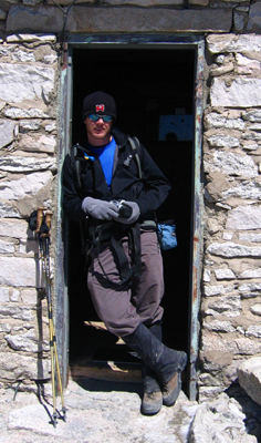
Me in the door of the summit hut on Whitney - not the place to be when weather rolls through...
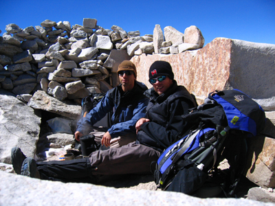
Brauning and I enjoying our summit coffee. This shat was taken a half a second before my digital camera rolled off the rock - no real damage.
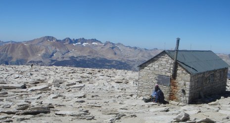
The Whitney Summit Rock House. Notice all the lightning rods on the roof. During storms the thing glows with electricity.
The rest of the trip down was uneventful and we made good time after deciding to skip Mt. Muir for the second time that day. Brauning was single and on the hunt for members of the opposite sex that are pleasing to his eye and share common interests with him. There were a few ladies coming and going on the trail as we descended that he tried to chat up with very little success – leading him to remark, “It is hard to be a player when you are carrying a bag of poo.” The man is a poet!
There was beer and pizza in Lone Pine after getting off the mountain. After a five hour drive, I walked in the door at home, scrubbed the three day crust off in the shower, and passed out with little beads of clean water still rolling off of me. It was a great weekend all and all and both Brauning and I got to knock a mountain off our tic-list, share some laughs, take in amazing scenery, and had the opportunity to successfully climb the tallest mountain in the continental US – not bad for two ol’ boys that live at the beach and wear flip-flops most of the time!
At the bottom of the trail just after we walked out on day two.